When I was in the second grade, we had a homework assignment to study a map of our neighborhood, memorize the names of the streets, and learn their order. This sounds like a reasonable homework assignment, until one realizes that even a rocket scientist with a map, a compass, a weather vane, and GPS would have a hard time figuring out where the hell he was going in Queens.
Originally, what is now the borough of Queens was 60 separate villages. These villages became Queens which was incorporated into New York City in 1898. In an effort to unify the streets across all these villages, someone came up with what many consider to be the most convoluted grid system in the universe.
In Queens, avenues run east and west and streets run north and south. Avenues have consecutive numbers, but often there are additional parallel streets in between the avenues that need to be called something, so they have been assigned the same numbers and called roads or drives, in that order.
So if there was a street between 65th and 66th Avenues, it would be called 65th Road. If there was another one, it would be called 65th Drive. Sometimes there are roads and drives between the avenues, sometimes there is only a road. Sometimes the avenues run consecutively with nothing in between. A destination that you originally thought was ten blocks away might be more like 30.
The same concept is applied to streets. If there is an additional street that needs naming between the consecutively numbered streets, they are called places and lanes. In some cases, streets aren’t even in numerical order. For example, if I walk from 99th Street where I grew up over to the next street, I hit 102nd Street. What happened to 100th and 101st Street? It’s across an expressway, several zip codes away. Easy Peasey.
Curved roads that are not parallel with either the avenues or the streets have numbers and are called crescents, courts or terraces. Addresses are hyphenated. The number before the hyphen is the cross street, and the number after the hyphen is the position on the block. For example, 62-38 99th Street is in the 38th position on 99th Street and has 62nd Avenue as the cross street. Note to native Queens residents. Don’t be impressed; I only recently learned all this from Wikipedia.
In some parts of the borough, there are stretches of named streets in between numbered ones, making this grid system pretty useless. These named streets were left over from the pre-grid days and retained by members of the community who thought the grid system was pretty lame. Several subway stations in the western part of Queens have retained the original street names, yet the corresponding street signs are numbers. Leave it to the MTA to mess with our heads by calling 46th Street Bliss Street Station and naming the stop at 33rd Street Rawson Street. The fancy schmancy section of Queens, Forest Hills Gardens, gave the finger to the grid system as well and retained their original names rather than numbers. Streets have names that follow the letters of the alphabet, something I can generally handle.
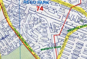
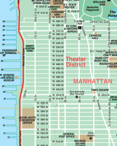
Below is a comparison of a map of a neighborhood in Queens versus one in Manhattan. Note the differences. For the Queens map, you can figure out where you are going by multiplying the distance by the square root of pi divided by 15, subtracting 2,982, and then adding 6.; this will get you to within 5 miles of your desired destination. To achieve the same task in Manhattan, all you have to be able to do is count.
The system is so convoluted that I can ask my mother, a resident of Queens for close to 50 years, to name the street or avenue two blocks over from her apartment and she cannot answer with 100% confidence.
As kids, we never said things like “meet me on the corner of 98th Street and 62nd Drive,” because no one knew where that was, even if it was just a block or two away. Instead we relied on landmarks as our meeting place and would say things like, “meet me in front of the drugstore; the one with the cashier with the 10 inch fingernails,” or “meet me under the Long Island Expressway at the place where my brother got mugged last week,” or meet me in front of that store that sells all the smelly cheese.” The only two streets that were ever referenced were Queens Boulevard (because the Boulevard of Death deserves that respect) and Austin Street because that was the high school equivalent of 5th Avenue in Manhattan.
When I moved to Manhattan, decades ago, being able to find my way around was like a breath of fresh air. I still marvel at the fact that 85th Street comes after 84th Street and Second Avenue is east of Third Avenue. When I return to Queens I will need to surround myself with the few geographically clairvoyant people I know from the borough who seem to have tackled this grid thing and can safely get me from point A to point B.


Pingback: Queens Stuff I Love, But Forgot About | Across the 59th Street Bridge & Back